Sample Reference: Standard-compliant system for web-based digitisation
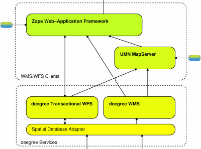
GIS structures in public administrations have been developed in a heterogenous way over many years. Different structures and data formats in various departments, local authorities etc. make it difficult to exchange and network the geodata. This has been the background for this project implemented on behalf of the district governments of Lower Saxony. An intermediate layer with interfaces based on the standards of the OpenGIS Consortium (OGC) realises an unified access on the hetergenous data sources for further applications.

To demonstrate the potentials of this concept the application "Web-based visualisation and digitisation of geo-objects" for digitising waste containers, bike paths and hunting areas has been developed.

Features:
- Visualising of data layers from diverse sources
- Digitising of geo-objects: points, lines, polygons
- Access restriction of visualising on particular applications
- Access restriction of digitising on particular regions of an application
- Communication with the components on server side exclusively by standard interfaces
- Web Mapping Service
- Transaction Web Feature Service
Free - Software components:
- deegree Services
- UMN MapServer
- Zope
- PostgreSQL/PostGIS
- Debian GNU/Linux or SuSE GNU/Linux
 Sitemap
 Deutsch